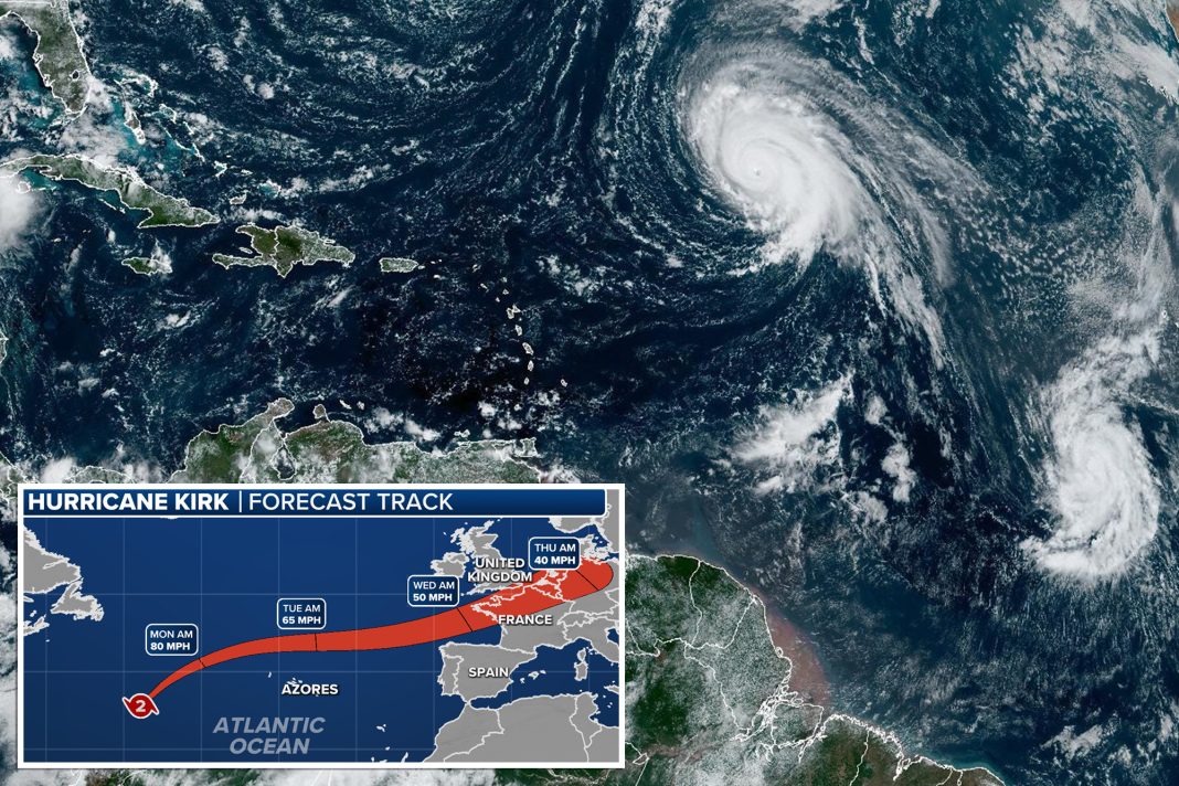
As the winds of change whip through the tropical Atlantic, parts of northwestern Europe brace themselves for a significant storm system originating from the tumultuous seas. Enter Hurricane Kirk, the 11th named storm of the 2024 hurricane season. This tempest, which peaked at a formidable Category 4 status, is now in a gradual descent, yet its remnants are set to unleash a barrage of heavy rainfall, turbulent seas, and gusty winds across the United Kingdom and France.
The journey of Hurricane Kirk began on September 29, when it appeared in the central Atlantic. With remarkable speed, it evolved into a major hurricane just days later. According to experts at the FOX Forecast Center, the hurricane’s path was distinctly influenced by the subtropical ridge’s orientation and a significant trough, which guided Kirk away from North American shores, including Bermuda and the Bahamas. Instead, the storm is charting a course northeast, a trajectory that has experts closely monitoring its potential impact on Europe.
As Kirk transitions into a post-tropical cyclone—losing its tropical characteristics but retaining enough organization to generate severe weather—the forecast models indicate that the storm’s effects will begin to manifest midweek. This transformation will not diminish its potency; rather, it will lead to conditions that could bring upwards of 5 inches of rainfall, along with wind gusts that may reach hurricane-force as the remnants of Kirk approach the European coastline.
The National Hurricane Center has issued warnings that swells from Kirk are already affecting the US East Coast, despite the storm being hundreds of miles away. This phenomenon is a stark reminder of the expansive reach of such storms. A noteworthy detail is that the tropical-storm-force winds from Kirk extend nearly 300 miles from its center, illustrating the vast influence of the storm even as it bypasses the US.
Looking back at historical precedents, Kirk’s remnants could possibly challenge records set by previous hurricane-originating storm systems. For instance, Hurricane Ophelia in 2017 is often cited as one of the most devastating storms to hit the UK in decades. With winds exceeding 70 mph and substantial rainfall, Ophelia resulted in significant damage and loss of life, prompting a national emergency response. Interestingly, despite the havoc wreaked by Ophelia, the name was not retired from the World Meteorological Organization’s naming list—an action typically reserved for storms that cause considerable destruction and fatalities.
Recent data from Met Éireann, Ireland’s national meteorological service, underscores the dangers associated with such storms. The organization reported that Ophelia produced winds that not only damaged numerous trees but also led to structural damage, including the collapse of an awning at a football stadium in Cork City. Such incidents serve as a stark reminder of the potential severity of post-tropical cyclones that were once hurricanes.
As Hurricane Kirk prepares to make its mark on Europe, it serves as a crucial reminder of the interconnectedness of global weather systems. The evolution from a tropical storm to a post-tropical cyclone exemplifies the complexities of meteorology, revealing how storms can continue to impact regions far from their origins. Residents in the UK and France should remain vigilant and prepared for the impending weather, keeping in mind the lessons learned from past storms. Ultimately, as climate change continues to influence weather patterns, the unpredictability of storms like Kirk may become an all-too-frequent reality, urging communities to prioritize preparedness and resilience in the face of nature’s fury.

